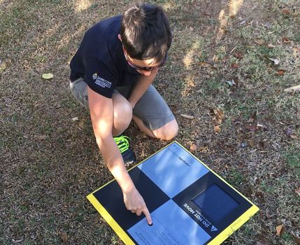
I have to say that I love testing new scientific toys. My latest acquisition is a set of Propeller Aeropoints. This is a set of ten foam targets with embedded GNSS that we place out in an area of interest before conducting a drone mapping mission. Why? Although my drones have onboard GNSS units, they are not always very accurate. This can make it difficult to know the exact location of a feature, and particularly challenging when trying to line up images to investigate changes over time. The aeropoints log their X,Y,Z location, and this can be used to correctly align a drone image mosaic.
Each Aeropoint is 0.5 x 0.5 m in size and despite being foam, it is a little heavier than expected, especially when impersonating a packhorse (does this make it ‘imanimalating’?) and carrying all ten. However, the weight is important as well so that they don’t blow away. Which they certainly don’t. Their low profile also ensures that they don’t move once set in place. Unless maybe in major winds, but in that case I wouldn’t be flying anyway. As for the size – well they need to be clearly visible in the imagery so they couldn’t be too much smaller either.
Pretty much all you need to do is spread out the targets around the survey area, turning them on as you go. They need to log for at least 45 minutes to get a good position fix, so it’s important to do this before having a cup of tea and setting up the drone. Simply fly the mission when ready, and collect the targets when done! As you collect each one, it will attempt to upload its data via your mobile device. If you’re not within internet range it will continue to try to connect until it’s successful. It can then take supposedly up to 24hrs to process the location data, but in the trials I have run, they were completed and available almost immediately.
Perhaps my favourite design feature about the Aeropoints is that they are solar powered. It’s a thumbs up for the environment and just one less set of batteries that I need to charge – I have enough of that to do with all of my drone equipment and other field sensors! So this is a really nice touch.
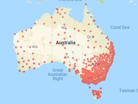
 Aeropoints coverage in Australia
 My least favourite aspect of this technology is the limited coverage of the correction network. Certainly much of SE Australia is well covered, but with red dots depicting coverage areas, the rest of the country looks like it has measles. I emailed to ask them about this and received the response “We are continuously expanding and increasing the coverage of our network; and, yes, your feedback and suggestions on prospect areas to focus on would be much appreciated.” So hopefully this improves over time.
Another note on their customer service while I’m at it. One of my Aeropoints was a dud, right out of the box. After checking a couple of things with them they quickly arranged a replacement, which arrived a couple of days later. Very easy.
In terms of actual performance, we compared the X,Y,Z values retrieved from the Aeropoints with those obtained by a local surveyor and achieved very pleasing results. I don’t know the system that the surveyor was using – I’m waiting to hear back from them and will update when I find out. The clear 1:1 relationship between the two sets of observations was honestly better than I expected.
In terms of actual performance, we compared the X,Y,Z values retrieved from the Aeropoints with those obtained by a local surveyor and achieved very pleasing results. I don’t know the system that the surveyor was using – I’m waiting to hear back from them and will update when I find out. The clear 1:1 relationship between the two sets of observations was honestly better than I expected.
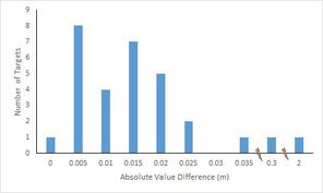
 Most pairings between Surveyor and Aeropoints have a difference of less than 2.5 cm. Note the discontinuity in the x axis to account for the points with larger discrepancy
 Out of the total number of 30 observations (X,Y,Z for each of ten targets), 27 had an absolute value difference of less than 2.5cm between the measurements of the Aeropoints and the Surveyor. The biggest problem was that Target 8 had a 2m discrepancy in elevation. But noting that the surveyors data were recorded by hand, I have to wonder if this is an error in transcription given the close alignment of all other points. But otherwise how do we know who's truth is the truth?
All in all, I'm pretty impressed with the Aeropoints and their ease of use. Given that my favourite field locations are out on the Great Barrier Reef, they will have limited immediate use for me as the correction network doesn't cover my sites, and of course the GNSS doesn't work underwater. Wouldn't that be awesome if it did!
Thanks to Tom Watson from Droner for collecting the data to support this.
Thanks to Tom Watson from Droner for collecting the data to support this.


 RSS Feed
